Introducing Curb Events
Traditionally, the curb has been thought of as a place to park vehicles; changes in travel patterns over the last couple years have pushed city stakeholders to rethink the use of the curb and leverage its broader value. With shared mobility programs joining public transit, private motorized and non-motorized vehicles, and pedestrians, the curb has become a hot commodity! Delivery pickup/dropoff, micromobility staging, and outdoor dining are just a few of the possible uses for the curb. Ride Report’s Curb Events tools are a curb manager’s best friend, making it easier than ever to plan and manage curb space.
Welcome to 21st century curb management!
Curb managers are tasked with the difficult job of prioritizing the use of miles of linear curb space, while creating and managing regulations with the specifics of feet and inches. In order to leverage the data source provided by shared mobility programs, they need to be able to view analysis at similar levels of granularity. Scooter clutter is a common complaint, particularly when vehicles are left outside of parking zones. Designated parking areas and corrals have proven to be an effective way to reduce this behavior, particularly when they are effectively located to match where users are going. The Curb Events tools not only lets curb managers look at a macro neighborhood level to view high intensity usage, but they also identify parts of blocks, side of street, and intersection corner where a corral would have the highest impact on clutter while taking into account other uses of the curb.
Managing stakeholder conversations with better data
A small number of vocal business owners and residents can make it seem like certain blocks have a disproportionate number of vehicles. With the Curb Events tools, program staff can track behavior over time in these specific areas to see if perception matches reality. Were those car share vehicles left there by the operator, or is it just a popular destination for users? Are e-scooter users dropping their vehicles off in front of a specific storefront more often than the one down the block? The Curb Events tools give you the answer to these questions at your fingertips, making you more informed when following up with these stakeholders or elected officials.
Iterative planning and infrastructure development
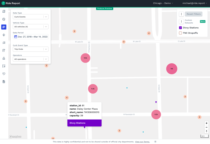
Using Curb Events in combination with Ride Report’s data layering visualizations, staff can compare proposed parking corral locations with historic data showing locations people naturally leave their scooters and bikes. The data layering capability can incorporate bus stop locations, food delivery hot spots, vehicle crash information, and other existing data sets to make informed decisions backed by the many historic uses of the curb. With the ability to incorporate any existing dataset, users can further leverage the insights provided by the rich shared mobility data already in Ride Report.
The insights provided by Curb Events tools are both retrospective and prospective, helping agencies find past conflict points, understand operator compliance, and plan future infrastructure. This integrated curb management solution uses detailed visualizations to inspire government agencies to ask new kinds of questions about whether or not the use of the curb is achieving its highest potential and where additional efforts should be directed.
Ride Report's full suite of solutions empower agencies to better and more easily manage the right of way. If you are interested in learning more about how the Curb Events tools can serve your team, please get in touch below!
 .
.